
|
1785 Land Patent for Elizabeth Helm Snidow (survey done in 1782)
and 1794 Deed of said land to Jacob Snidow:
Click here to print a copy of the Survey.
(The survey appeared in the Snidow Newsletter Vol. 12, No. 2, p. 3 – Autumn 1989 issue)
And the following is from the Snidow Newsletter Vol. 1, No. 2, p. 3 - November, 1978 – Mary French Boswell's article "The Land Patent of Elizabeth (Helm) Snidow on New River"....
When the Snidow family arrived in the New River Valley, the area was part of Botetourt Co. The Inventory of the estate of John Shnido (Sept. 1772) is recorded in Fincastle, the county seat. In 1777 Montgomery Co. was cut off from Botetourt and the area that later became Giles Co. was a part of the new county. It is in Christiansburg at the court house that is found the first reference to land claimed by Elizabeth Helm Snidow.
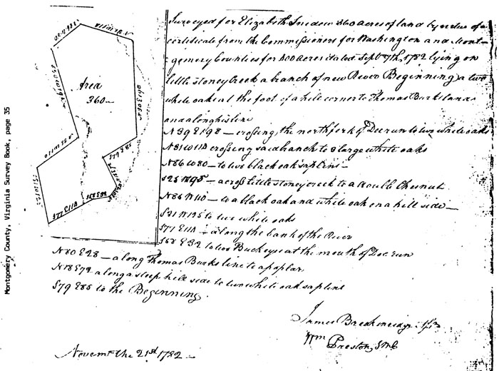
In Montgomery Co. Record of Plotts, Book B, p. 35, there is a Survey of Land for Elizabeth Snidow which reads, "–––360 acres of land by virtue of a certificate from the Commissioners for Washington and Montgomery Counties –– dated Sept 7th 1782 lying on little Stoney creek a branch of New River–––". It was signed by Wm. Preston, Surveyor for Montgomery Co. In Richmond on the 1st of Sept. 1785 Elizabeth Snidow received a Land Patent for this land, signed by Patrick Henry, Governor of Virginia. (Virginia Land Office Grants, Book "O", p. 255, as found in the Archives Division, VA
State Library.)
Nine years later Elizabeth Snidow deeded this land to her youngest son, Jacob. Below is the deed – the
description of the land identical to that of the Survey and to the Land Patent -- as found in Montgomery Co. Va. Will and Deed Book "B",
p. 167.
This Indenture made 2nd August 1794 between Jacob Snidow and Elizabeth Snidow for 100 pounds Current Money...a tract of land
containing 360 A. 'and being granted to the said Elisabeth Snidow by Land Patent bearing date the first of Sept 1785 lying and being in the
county of Montgomery on Little Stony creek, a branch of New River and bounded as followth, To wit,
Beginning at two white oaks at the foot of a Hill corner to Thomas Burk's land and along his line North thirty nine degrees East one hundred
and Ninety eight poles crossing the North fork of Doe Run to two white Oaks
North thirty one degrees west one hundred and fourteen poles Crossing said Branch to three large White Oaks
North 86 degrees West 80 poles to two Black Oak Saplins
South 25 degrees West 195 poles Crossing little Stony creek to a Double Chestnut Oak
North 85 degrees West 110 poles to Black Oak and White Oak on a hillside
South 31 degrees West 125 poles to two White Oaks
South 77 degrees East 114 poles along the Bank of the River
South 58 degrees East 31 poles to two Buckeyes at the mouth of Doe Run
North 80 degrees East 28 poles along Thomas Burk's line to a poplar
North 18 degrees East 72 poles along a steep hill side to two white Oak Saplins
South 79 degrees East 85 poles to the Beginning.
To Have and to Hold,
Signed by Elizabeth Snidow (her mark)
Witnesses: C. Snidow, John Snidow, William McComas
This land of Elizabeth Snidow on New River between the mouth of Doe Creek and the mouth of Little Stony Creek and extending on both sides of Little Stony up toward the mountains covered a big part of what today is the town of Pembroke, VA
At the present time we do not know when Elizabeth died. She was living in 1794. It is thought that she lived at least until after 1798, as, on that date, a survey of land was found in Montgomery Book of Plotts in which land of Elizabeth Snidow was mentioned and it did not record that she was deceased as would have been the custom if she were no longer living.
Written by Mary French Boswell
|
|
|
|
|